It’s happening again. Or rather, it’s happening bigger.
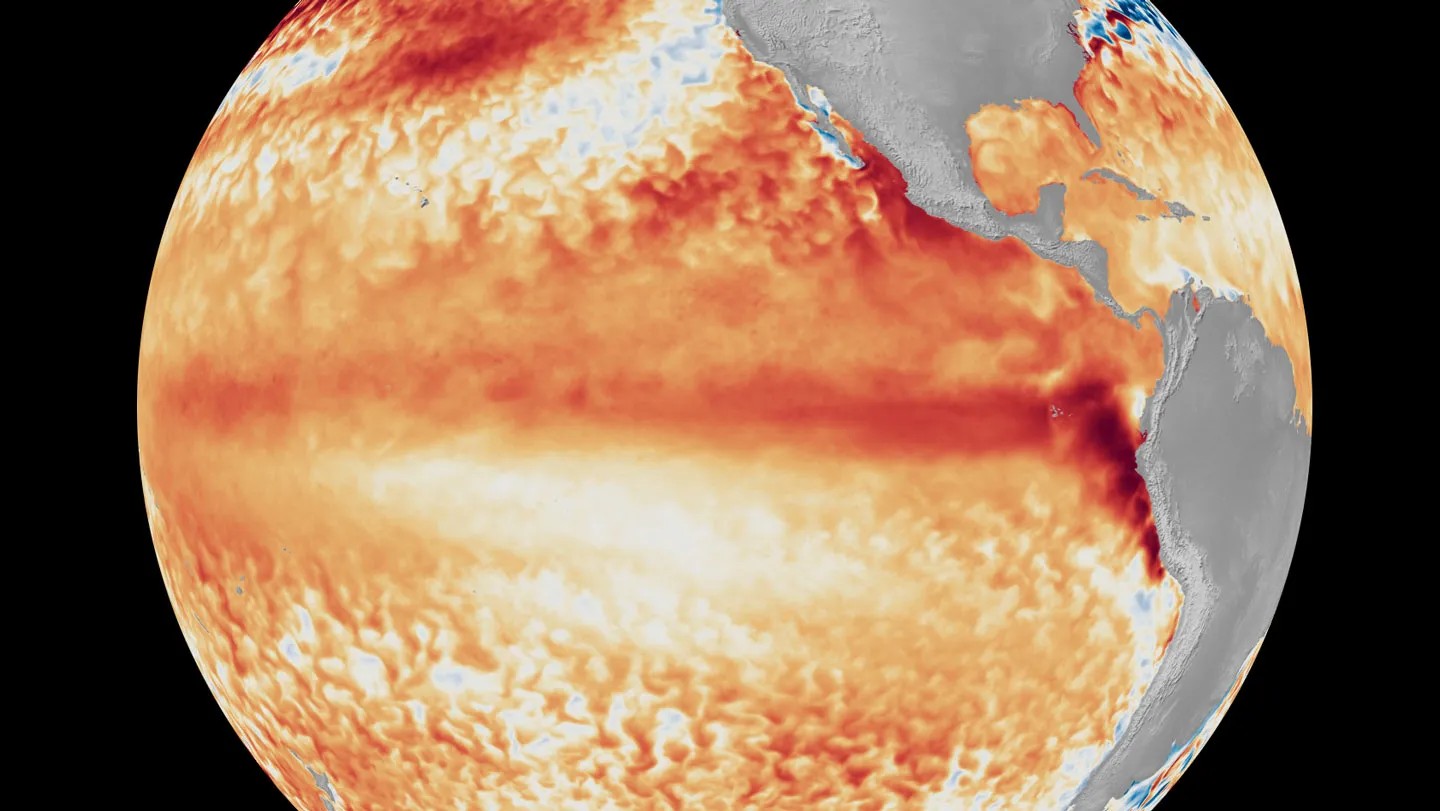
Meteorologists at the National Oceanic and Atmospheric Administration (NOAA) are watching a “super” El Niño emerge from the depths of the Pacific Ocean. This isn’t your grandfather’s seasonal weather shift. It’s a massive, long-duration heating of the ocean’s surface that doesn’t just tweak temperatures—it rewrites the rules of global weather for months, sometimes years.
But why should you care?
Because a super El Niño is essentially a global reset button for the climate system. It disrupts everything from hurricane tracks to rainfall patterns, triggering a chain reaction that can leave some places drowning and others burning.
What Exactly Is a ‘Super’ El Niño?
To understand the scale, you first have to understand the baseline. El Niño is part of the El Niño-Southern Oscillation (ENSO), a natural cycle in the Pacific near the equator. Normally, trade winds push warm surface water toward Asia and Australia. In the eastern Pacific, near the Americas, cold, nutrient-rich water rises up from the depths—a process called upwelling. This keeps the air cooler there.
An El Niño event occurs when those trade winds weaken. The warm water sloshes back east, towards the Americas. Scientists officially declare an El Niño when the sea surface temperature in the eastern and central equatorial Pacific rises by at least 0.4 degrees Celsius (0.72 degrees Fahrenheit) above the average for five consecutive months or more.
A super El Niño takes this baseline and cranks it up.
It involves stronger winds initially building up in the west, followed by an even more dramatic collapse. The result? Warmer water than usual piles up against the Americas, creating a massive heat reservoir in the Pacific. The thermal energy released from this warming water into the atmosphere is intense, powerful enough to influence jet streams thousands of miles away.
Why Does It Matter for Global Climate?
The atmosphere is a chaotic engine. You add heat in one place, and the engine adjusts. A super El Niño dumps so much heat into the Pacific that it alters the jet stream—a fast-flowing, high-alt air current that steers weather systems across mid-latitude regions.
This shift in the jet stream causes predictable, yet extreme, disruptions around the world.
In North America, the changes are immediate and visceral. The altered jet stream often brings heavy rainfall and flooding to the U.S. West Coast. It’s not just rain; it’s atmospheric rivers that can wash out roads and cause mudslides. Meanwhile, the southern United States tends to see milder, wetter winters, while the Pacific Northwest can experience unusually cold and snowy conditions. Ice storms and mudslides become common headlines.
In South America, the heavy rains intensify. This leads to catastrophic flooding along the western coast, including countries like Peru and Ecuador.
In Asia and Australia, the pattern flips. The warm water stays put, suppressing rainfall. This leads to extended droughts. Dry vegetation plus high temperatures equals high risk of wildfires. Australia and Southeast Asia can face severe heatwaves and water shortages.
Why does this specific type of El Niño have such a disproportionate impact? Because it amplifies the background noise of climate change. Human activity, particularly the burning of fossil fuels, has increased levels of greenhouse gases like carbon dioxide and chlorofluorocarbons. These gases trap heat, making the baseline temperature higher. When a super El Niño layers on top of this already-warming planet, the extremes become more severe.
What About Disease and Ecosystems?
The impacts aren’t limited to property damage or crop failures. A super El Niño is a public health and ecological trigger.
Coral reefs, those stony structures built by marine animals that often live on reefs, are under threat. When ocean waters stay too warm, corals expel the algae that give them color and food. This is coral bleaching. It can lead to mass death, disrupting marine ecosystems for decades.
Disease outbreaks also spike. The connection between water and illness is direct.
- Cholera: A bacterial disease that infects the computer models… wait. Cholera. A bacterial disease that infects the human small intestine, causing severe diarrhea, dehydration, and vomiting. It is spread by germs (Vibrio cholerae) that contaminate water supplies with fecal matter. During El Niño events, flooding can overwhelm sewage systems, leading to cholera outbreaks.
- Malaria: A disease caused by a parasite invading red blood cells. The parasite is transmitted to humans by mosquitoes. Warmer temperatures accelerate the lifecycle of mosquitoes, increasing their breeding rates and range.
- Rift Valley Fever: A viral disease originally identified in the Rift Valley of East Africa (a geologic rift where the Earth’s crust is splitting apart). Mosquitoes spread it to people and animals. While humans usually experience mild symptoms like fever or dizziness, livestock often suffer severe sickness or death. Pregnant animals may lose their fetuses. Crucially, outbreaks frequently follow heavy rains, which create breeding grounds for the mosquitoes.
The Ocean’s Role in the Bigger Picture
We often talk about climate change as a slow creep. But ENSO events remind us that the ocean is the planet’s heat battery. It absorbs vast amounts of energy.
During La Niña—the opposite phase of the cycle—surface waters in the eastern Pacific cool. This often reverses the weather impacts: Central and South America may face droughts while Australia sees floods. But a super El Niño represents a peak in heat retention.
How do we know it’s coming? Meteorologists use complex computer models —programs that simulate real-world phenomena—to track sea surface temperatures and atmospheric pressure. These models look for signs of the trade winds weakening and heat accumulating in the central Pacific.
When these models align, the result is a forecast that should concern everyone, not just those living on the coastlines.
The Uncertainty Ahead
A super El Niño doesn’t guarantee specific disasters in your hometown. But it raises the odds.
It increases the likelihood of tropical cyclones (strong, rotating storms with winds exceeding 119 kilometers or 74 miles per hour). In the Atlantic Ocean, these are hurricanes. In the Pacific, they’re typhoons. The warmer sea surface temperatures provide more fuel for these storms to strengthen.
It threatens food security through drought in key agricultural zones. It strains water resources in the American Southwest. It endangers biodiversity in the reefs.
We cannot control the Pacific Ocean. We cannot stop the trade winds from shifting. But we can prepare. We can understand that the weather events we are seeing—the floods, the fires, the heatwaves—are not isolated incidents. They are parts of a connected system, driven by the same forces that are warming our planet.
The super El Niño is here. The question isn’t whether it will impact the world. It’s whether we’re ready to handle what comes next.
“The atmosphere is a chaotic engine.”
It’s just getting started.